When determining where the new ward boundaries should be redrawn, staff considered the following criteria:
- Effective representation - voters should be equally represented to the greatest extent possible
- Representation by population - population numbers should be relatively equal in each ward
- Population trends and growth - ensuring the new boundaries can accommodate planned growth and intensification
- Geographical features, such as natural and built boundaries - ensuring the boundaries follow built or natural boundaries, such as major roads and rivers
- Protection of established neighbourhoods and communities - ensuring areas such as Mount Pleasant or Springdale, for example, are not divided between wards
There are two (2) options for boundary realignment. Both options meet the criteria and are designed to cover the next three (3) municipal election cycles - 2026, 2030 and 2034.
Maps of the realignment options are included below. To view a version of the maps that contain the projected population forecasts for the next three (3) election cycles, click the following links for
Option 1 and
Option 2.
Realignment Option 1
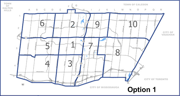
Where are the changes?
- Ward 1 is bordered by Queen Street, Highway 410, Bovaird Drive, and McLaughlin Road North
- Ward 2 is bordered by Bovaird Drive, Highway 410, Mayfield Road, and Chinguacousy Road
- Ward 3 is bordered by the southern city limits, Highway 410, Highway 410, Queen Street, and McLaughlin Road South
- Ward 4 is bordered by the southern city limits, McLaughlin Road South, Embleton Road and Queen Street West, and Winston Churchill Boulevard
- Ward 5 is bordered by Embleton Road and Queen Street West, McLaughlin Road North, Bovaird Drive West, and Winston Churchill Boulevard
- Ward 6 is bordered by Bovaird Drive West, Chinguacousy Road, Mayfield Road, and Winston Churchill Boulevard
- Ward 7 is bordered by the southern city limits, Torbram Road from the southern city limits to Queen Street East, Queen Street East from Torbram Road to Bramalea Road, Bramalea Road from Queen Street East to Bovaird Drive East, Bovaird Drive East, and Highway 410
- Ward 8 is bordered by the southern city limits, Highway 50, Castlemore Road, Bramalea Road from Bovaird Drive East to Queen Street East, Queen Street East from Bramalea Road to Torbram Road, and Torbram Road from Queen Street East to the southern city limits
- Ward 9 is bordered by Bovaird Drive East, Torbram Road, Mayfield Road, and Highway 410
- Ward 10 is bordered by Castlemore Road, Highway 50, Mayfield Road, and Torbram Road
Realignment Option 2
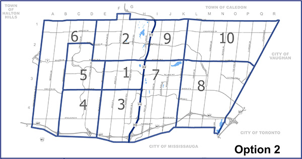
Where are the changes?
- Ward 1 is bordered by Queen Street West, Highway 410, Bovaird Drive West, and McLaughlin Road North
- Ward 2 is bordered by Bovaird Drive, Highway 410, Mayfield Road, and Chinguacousy Road
- Ward 3 is bordered by the southern city limits, Highway 410, Queen Street West, and McLaughlin Road South
- Ward 4 is bordered by the southern city limits, McLaughlin Road South, Queen Street West, and Mississauga Road
- Ward 5 is bordered by Queen Street West, McLaughlin Road North, Bovaird Drive West from McLaughlin Road North to Chinguacousy Road, Chinguacousy Road from Bovaird Drive West to Sandalwood Parkway West, Sandalwood Parkway West, and Mississauga Road
- Ward 6 is bordered by the southern city limits, Mississauga Road, Sandalwood Parkway West from Mississauga Road to Chinguacousy Road, Chinguacousy Road from Sandalwood Parkway West to Mayfield Road, Mayfield Road, and Winston Churchill Boulevard
- Ward 7 is bordered by the southern city limits, Torbram Road, Bovaird Drive East, and Highway 410
- Ward 8 is bordered by the southern city limits, Highway 50, Castlemore Road, and Torbram Road
- Ward 9 is bordered by Bovaird Drive East, Torbram Road, Mayfield Road, and Highway 410
- Ward 10 is bordered by Castlemore Road, Highway 50, Mayfield Road, and Torbram Road
Next Steps
Following the public consultation phase, resident feedback will be shared with Council in a Council Workshop. Staff will present a report at Committee of Council in the new year seeking a decision on the next steps. Council may adopt a realignment option with the new ward boundaries taking effect after the next municipal election in October 2026. This may affect where you vote and who you vote for. Be sure to check often for updates on the project.
Questions?
Visit the
Project Library page to view all staff reports and presentations, and to watch recorded meetings. Further questions or comments can be sent to
wbr@brampton.ca