City of Brampton Logo

Planning for the Future

​​​​​​​​​​​​​​​​​​​​​​​​​​​​​​​​​​​​​​​​​​​​​​​​​​Proposed Planning Approaches

There are three potential ways to implement Queen Street Bus Rapid Transit and address future transportation needs within the corridor:

​​
  • Converting two general-purpose lanes into dedicated transit lanes, and reallocating some of the auto-vehicular capacity into capacity for rapid transit, requiring minimal widening of the roadway. There would likely be limited widening of the right-of-way to accommodate boulevard improvements and other roadwa​y improvements.


  • Widen the roadway and the right-of-way to introduce dedicated transit lanes and maintain the existing number​ of general-purpose lanes, resulting in an overall increase in transportation capacity. This will likely have major property impacts along the corridor where right-of-ways are insufficient. The width of the roadway at intersections would also be widened as a result.


  • Convert curb lanes into reserved lanes for buses and HOV lanes. This requires no roadway widening but has less capacity to accommodate rapid transit, and will be less effective in achieving transit-priority compared with dedicated transit lanes. There would still likely be limited widening of the right-of-way to accommodate boulevard improvements and other roadway improvements.

An assessment of needs and transportation modelling is underway to evaluate the three approaches and aide in the selection of a preferred approach.

Why Bus Rapid Transit?

Integration with Viva Highway 7 BRT and Dedicated Lanes
The current Züm service along the Queen Street/Highway 7 corridor offers a continuous, inter-regional connection between Downtown Brampton, Vaughan Metropolitan Centre, and York University.

The most popular service operated by Brampton Transit

~19,000 boardings on a typical weekday (Fall 2017)

Weekday ridership grew on average 7% per year between 2011 and 2017.​​​

The 2013 Benefits Case Analysis (BCA) found that the most important outcome of a Queen Street/Highway 7 rapid transit corridor is ​to provide continuous service. For example, forcing customers to transfer from a light rail vehicle in Brampton to another service provider midpoint in their journey, will make rapid transit unattractive to riders, not offering any benefits over the existing Züm service in mixed traffic. This will result in less ridership potential for the corridor, a finding reaffirmed by this study.

York Region and Metrolinx are currently implementing dedicated transit lanes (branded “Rapidway”) for BRT operation along the Highway 7 East and Highway 7 West corridors. Construction is currently underway along the Highway 7 West corridor between Richmond Hill Centre and Helen Street/Bruce Street in Vaughan. Züm service on Highway 7 is planned to operate on the new Rapidway upon completion.

York Region is currently working to secure funding to extend the Highway 7 West Rapidway from Helen Street to Hi​ghway 50 for BRT operation. As such, it would be important for Queen Street Rapid Transit to share a common transit mode with York Region Transit’s VIVA BRT.


Flexibility
BRT accounts for physical constraints within the Downtown Brampton area. With major transformations underway in the downtown area (Downtown Reimagine Project, Ryerson University campus, the future Centre for Innovation, and the potential future expansion of the Downtown Transit Terminal), the preferred solution for Queen Street Rapid Transit would need to be operationally flexible to respond to the changing landscape of the downtown. BRT is advantageous because it is operationally flexible, less infrastructure-intensive, and less costly to implement.

Future Ready
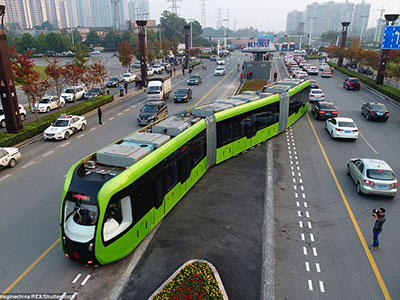
While BRT is the proposed starting point for Queen Street Rapid Transit, an important requirement for the project will be that the design of the corridor allows for future upgrades in capacity, infrastructure, technology (e.g. electric propulsion, vehicular automation, autonomous vehicles, Smart Lanes), or conversion to light rail if warranted. Recognizing the emergence of new and evolving transit technologies in the industry, the proposed transit solution is flexible enough to adapt to the changing technological environment.

Electric Buses


High Capacity Buses


​Vehicular Automation, Autonomous Technology


Complete Streets Approach

The desired outcome for Queen Street will be directed by policy established for streets by the Greater Golden Horseshoe Growth Plan, Peel Region’s Official Plan, the City of Brampton’s Official Plan and Transportation Master Plan, the recent Brampton 2040 Vision, and the ongoing Brampton Complete Streets Study. Each policy speaks to the inclusion of Complete Streets; an approach to street planning and design that considers the needs of all users and uses.

All of the street design options to be developed by the consulting team will strive to achieve two fundamental principles:

Context Streets Approach

Fundamentals to Complete Streets is that streets are places that exist for all street users; moving beyond designing streets to satisfy only an auto-centric transportation role and function.

Focus of Traditional Approaches:
​Auto Mobility
Automobile Safety

Complete Street Appro​ach:
Multi-modal Mobility + Access
Public Health & Safety
Economic Development
Environmental Quality
Livability / Quality of Life Equity

​​​A Proportional and Equitable Street

Having adequate space for non-vehicular users is important to create inviting and vibrant city streets that are places as well as corridors for movement. Working from the Outside-In, the street can provide a comfortable proportion that can support and encourage public life.


​A series of typical street design options are being developed for the Queen Street corridor with dedicated transit lanes in three possible configurations. Each of the options presents a change to the design of Queen Street from the existing condition.

  • Centre Median Transit Lanes: the most common arrangement for rapid transit corridors like Queen Street, featured in most jurisdictions that operate at-grade rapid transit.

​​

  • Curbside Transit Lanes: transit operating in dedicated lanes adjacent to the curb is another common arrangement for corridors like Queen Street, but is less effective in achieving transit-priority, and comes with a greater impact to midblock vehicular access.


  • One-Side Transit Lanes: transit in dedicated lanes adjacent to one side of the road (north or south, east or west) is not a typical arrangement, though it can be found in other jurisdictions in short segments along a corridor as a solution to a localized need or constraint. Any crossing over the transit lanes would require a signalized intersection.


The design options are intended to test a range of transit, roadway, and boulevard configurations within a 40, 45, and 50-metre right-of-way which is a general reflection of the Queen Street corridor east of Centre Street. One or more options are possible for the length of the corridor.​

Major Transit Station Area

Major Transit Station Areas (MTSAs) are the areas around existing or planned higher order transit stations or stops. Provincial policies require these areas, generally within 500 metres or a 10 minute walk of a rapid transit stop, to be planned and designed to support transit use with multimodal connections, a diverse mix of land uses, and minimum targets for population and employment densities.

With Queen Street Bus Rapid Transit, the area around each rapid transit stop will be considered as an MTSA, and for the purpose of the Queen Street Study. All of the existing Züm station stops along Queen Street are being considered as potential rapid transit stops and potential MTSAs.

Of the 16 potential MTSAs along the Queen Street Bus Rapid Transit corridor, eight have been identified as focus areas:

  • Brampton GO Station Area
  • Queen Street Central Area (between Kennedy Road and Rutherford Road)
  • The Bramalea neighbourhood (between Dixie Road and Central Park Drive)
  • Gateway Boulevard Node
  • Goreway Drive
  • The Gore Road

Focus areas are defined as areas that have a capacity to accommodate future residential, mixed-use, or employment growth, and where transit services converge. Each focus area has a different land use context and planning priorities. The Queen Street Study land use planning priorities and urban design guidelines will be identified to support Queen Street Rapid Transit.​


Contact the Project Team

Share your comments and suggestions regarding planning for the Queen Street - Highway 7 Bus Rapid Transit (BRT). Visit the Metrolinx Queen Street - Highway 7 BRT Contact Us page.​​​​​